
Its a great time of year to be cycling, as the koinoburi (flying carp wind socks) are out for childrens day on May 5th and make the scenery even more colourful. Often many flying carp are strung from long ropes tied across narrow valleys.
Also the rice fields are now being flooded with water for the first time, and this is good news for frogs. The sound of the frogs croaking in the rice fields is a distinctive sound of this time of year, late spring.
Most of the TCC regulars have taken off to tour parts of Japan over this holiday, but as I was recently in Okinawa I've been based in Tokyo and used the holiday to explore more toge in the Tokyo/Yamanashi/Kanagawa prefectures. Toge means mountain pass, and the kanji 峠 has the components mountain, up and down which is a very iconic representation of the word for mountain pass, and sums up the 3 rides Ive done over the last week.
The first ride was based around Takao san and featured closed road sections east and west Jimba onsen as well as Wada toge north. Small mountain roads are often closed due to landslides, but its easy to get around the gates on a bike and often the roads are in excellent condition and of course traffic free. You often see monkeys on these roads, and some people have encountered wild boar on the deserted roads. Ive done this circuit before, its only 75km but theres no flat, and with 2000m of ascent its an excellent training route which can be done in a morning then get home early.


 Daibusaturei toge is a tough climb, over 700m straight up with several steep sections. The summit of Daibisaturei is over 2000m and the pass at 1600m is full of hikers refilling water bottles with mountain spring water and eating at a lodge ready to set off for the summit.
After a very long descent southwards the road eventually reaches route 20, and the choices here are go through a 3km tunnel, climb another 400m pass to avoid the tunnel or get the train back from Kaiyamoto. It felt great to have been over the 3 big climbs, and to save more for the final golden week ride.


At Otsuki, I was so tempted to take the train back as Id already done 85km and the temperature was around 30 degrees. But after some glucose and caffeine from the combini, and a rest in the shade I summoned up enough strength to head south another 10km then over the final major climb over route 24 out of Tsuru town and over to the Doshi road. This was a nice easy climb, again very long but Id do this one again.
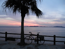
To have the koinoburi pointing your way along the Doshi michi is all you can hope for, as this route drops from Yamaguchiko in the west all the way to Sagamihara, on the foothills before the Tokyo plain. So its downhill with the wind behind, and the total 185km for the day was large, but thoroughly enjoyable, scenic and great to explore more of the distant hills before the summer arrives.
Gas station?
ReplyDeleteWhat next intersection? One more reason you make me sick.
The offending word gas station has been removed, I have replaced it with ガソリンスタンド.
ReplyDelete