First convenience store stop of the day when I meet the 445, as its unlikely to find any shops after this point. A group of Sunday morning cyclists is gathered, all buying their calorie mate energy bars, energy gels, pokari sweat drinks and other snacks ready to burn the calories. I tell them Im off to Takachiho, and they all seem amazed - tough route, many mountain passes, long distance. I'm glad I didn't pay too much attention to them, it was a really nice route!
Just beyond the junction of 445 and 218, theres a local legend called the Tsūjun-kyō Bridge. From pictures it seems to be an aqueduct that leaks a massive fountain of water from its central point. But it only does this once a day, at midday for 10 mins. Nice to get a short rest here, but no need to wait another 1.5hr to see the leaking bridge. Still seemed like the crowds were gathering, at least I could get ahead of them and have a quiet road for the next hour or so.

Takachiho is famous for its deep gorge, and I soon find my heavy bike and luggage being sucked down an ever steepening valley down to the narrow river below which carved through this section of rock. Dont be fooled by the boat trip, its ¥1500 per person and you dont get to paddle up the gorge - just paddle around a pool and get slightly close to the waterfall and main gorge area.

So that night I slept somewhere along the 325, I found a nice path to the back of a grove of trees with a decent view of the setting sun. No view of Aso san yet, as I had hoped. I found a large cage, must have been a trap for a large animal such as tanuki but nothing went clank in the night.
That extra distance along 325 set me up for a great day up to Aso san, the volcano which sits inside the worlds biggest caldera. So that naturally means you'll get 3 big climbs doing this ride. Up and down into the caldera, up and down Aso san itself, then up and down to exit the caldera, that is unless you take the west exit which appears to be a spot where the giant caldera wall was washed away.
Climbing route 111 is one of the best roads on the tour. Almost zero traffic, gentle 4-5% gradient and amazing views on a day like today. I'm lucky with the wind direction again, as the sulphuric gas is blowing away from the viewing platforms and so the summit is open. I have visited Aso san many years ago by train and bus, but that day the clouds were down, raining and the ropeway was closed so this day was much more memorable.
I stopped at the vistors carpark
 and took the ropeway to the summit, only to look down on a perfectly decent road winding its way to the top! Yes, its perfectly fine to cycle up this road as well, so save yourself some yen and cycle up this section or you'll be stuck in an omiyagi shop waiting for the next lift up or down!
Impressive crater, but worrying being so close to another active volcano and the concrete shelters which dotted around the visiting area looked very feeble, I really wouldnt want to have to take cover in these huts. But at least the falling ash would warm things up, it was freezing at craters edge.
The descent is sweet, again very gentle 4-5% so never too fast. After Aso village, head east then north onto route 11, the start of the Yamanami (mountain wave!) highway. All the way down Aso and then up and out of the caldera the landscape was quite alien. Blackened trees, blackened bushes and ash everywhere but this wasnt due to the volcano but controlled annual burning of the vegetation by park keepers.
Once you get to the junction
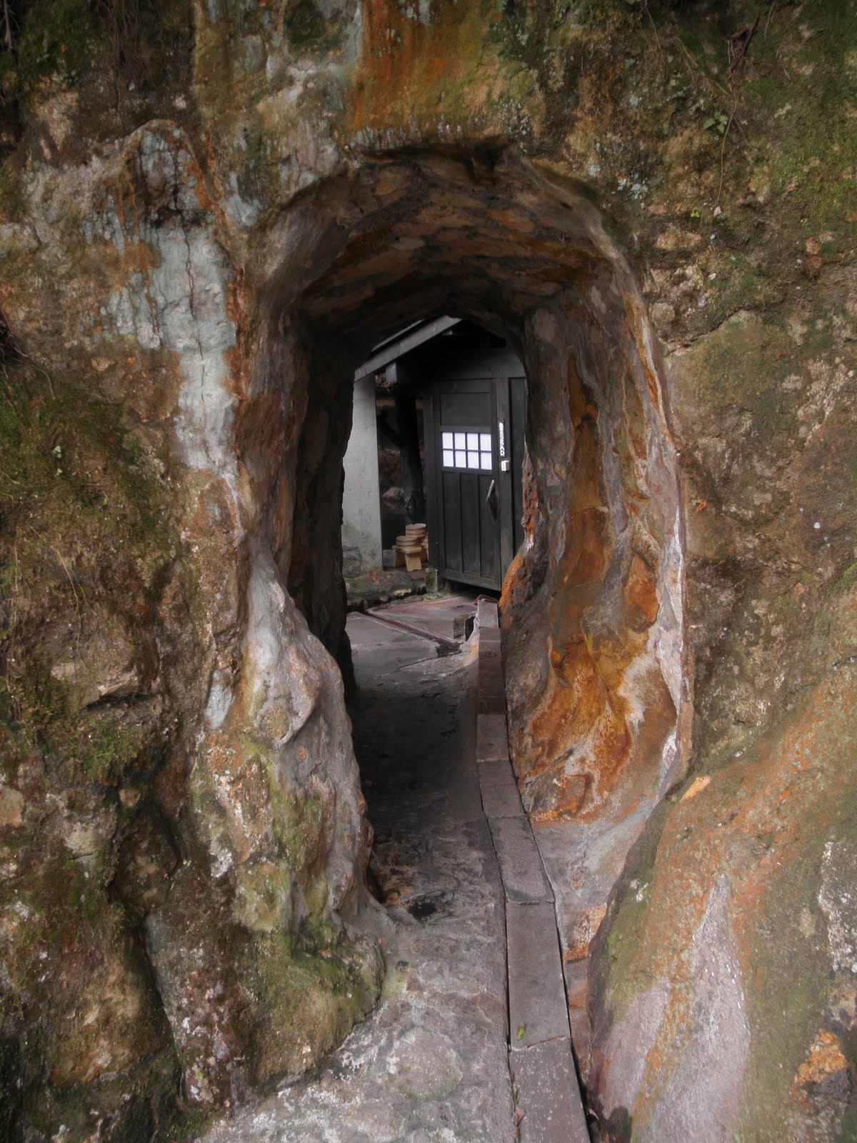 of 442, make a detour left 6km to Kurakawa onsen. I agree with the judges who voted this the best onsen town in Japan! Its a high class village, virtually all the buildings are expensive ryokan each hosting spectacular onsen. Some are in caves, most are outdoors, some are mixed bathing and most ryokan will have private onsen if you so wish. You can visit any of them for ¥500 but the best way to visit is to buy a 3 onsen wooden pass. They will take a stamp off the pass and stamp your pass with the seal of the ryokan, so making a nice souvenir. I visited the outstanding Shinmeikan with its interesting cavern system of onsen. The whole place had a very rustic feel, I liked the log fires heating up kettles for green tea.
 As the cheapest place to stay was ¥15900, I was happy to cycle a very easy
 2.4km over a small hill to the next valley and Shoda onsen, where the minshuku Yumeno-yu is a mere ¥6500. Its massive, has fantastic food, great rooms and the village has many nice rotemburo so a nice alternative to the Kurokawa luxury resort. After evening meal I still had time to cycle back over the hill and sample the waters of Yamabiko ryokan in the moonlight. Todays onsen and minshuku definitely made up for the previous nights cold, cold camping by the roadside.
 Still freezing overnight,
 frost in the morning and so I was able to use up my 3rd onsen stamp at Okunoyu with its riverside rotemburo. Really nice, I was in no hurry to leave this place especially knowing the main asecnt on the yamanami highway was just around the corner!
I had a few hours to kill before my ferry to Matsuyama on Shikoku, so I followed the advice of the information center to cycle over to Hyotan onsen with the hope of taking a hot sand bath. Alas, its Tuesday and the center is closed - but this is Beppu and so only 50 m away theres another onsen which is open. I take a hot steam box sauna , nice rotemburo. The indoor onsen even has TV screens around the bath, but as the pictures are all about tsunami victims and the raising of the Fukushima incident to level 7, it doesnt make for a relaxing time in the bath!
No comments:
Post a Comment